

Project to Protect the Capital Remains Stalled
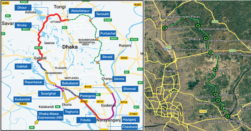
- Eastern Bypass Road / Inner Circular Road
- The Road Will Serve as a Flood-Control Embankment While Creating New Opportunities for Planned Urbanization and Economic Activity in Eastern Dhaka
- Building the Entire Project as a Surface-Level Main Road Instead of Elevated Would Cut Costs, Ensure Optimal Land Use, and Bring Transformative Change to Local Connectivity
Eklas Haque
With the three goals of easing traffic congestion in eastern Dhaka, building an alternative communication system, and controlling flooding, the government took up the Eastern Bypass Road, or Inner Circular Road, project more than three decades ago. But despite passing through a long process of planning, surveys, design, and changes of department, the project still awaits implementation. As a result, hundreds of thousands of people in the capital’s eastern part remain deprived of the benefits of a promising infrastructure project. If this proposed road is implemented, it would ease pressure on the capital’s conventional internal road-dependent communication system. At the same time, the road would serve as an embankment for flood control while creating new opportunities for planned urbanization and economic activity in eastern Dhaka. A key feature of the proposed project is that it is not merely a road, but a large-scale infrastructure integrating urban management, flood control, and economic development.
Asked about the matter, State Minister for Road Transport, Bridges, and Railways, Mr. Habibur Rashid Habib, told Inqilab that although eastern Dhaka has expanded, the region’s communication infrastructure has long failed to keep pace with the city’s overall growth. Although population and commercial activity have increased in areas such as Rampura, Bonoshree, Nandipara, Demra, Amulia, Tarmukh, and Beraid, many roads are still struggling to handle vehicle pressure. The Eastern Bypass Road, or Inner Circular Road project, is being viewed as a regional connectivity corridor. According to the project plan, the road will loop around eastern Dhaka to create a network that allows vehicles from the north, east, and southeast to reach their destinations without entering Dhaka. The benefits of this project’s implementation will not be limited to reducing traffic congestion or enabling faster travel alone. If implemented, the quality of life for people across a vast area of east Dhaka will also improve significantly. Alongside improved road connectivity, the risk of flooding and waterlogging will decrease, and new opportunities for business and employment will emerge. New doors of possibility will also open for urban expansion and economic development.
Professor Dr. Hadiuzzaman of the Civil Engineering Department at Bangladesh University of Engineering and Technology (BUET) told Inqilab that a major problem with Dhaka’s road system is that traveling from one end of the city to the other requires passing through the central area, forcing even vehicles whose destination is not within Dhaka to use the city’s busy roads. If a portion of the vehicles coming from the airport, Abdullahpur, Tongi, Gazipur, and northern Bangladesh could be diverted onto an eastern alternative route, pressure on the city’s key roads would ease. One of the most important features of the Eastern Bypass project is that the road would serve not only for vehicle movement but also as flood-control infrastructure. The eastern parts of the city are connected to wetlands, low-lying land, and natural water flows. He said that if proper embankments, culverts, sluices, drainage, and water-discharge systems are integrated alongside road construction, it would create communication infrastructure on one hand and, on the other, build a system to help address waterlogging and flood risk.
He said that building the entire project as a surface-level main road in the eastern region, instead of making it fully elevated, would significantly reduce costs. At the same time, it would ensure optimal use of acquired land and allow the project to be implemented faster. This would create a circular communication system and an effective alternative connectivity corridor across the entire capital, covering areas including Abdullahpur, Beraid, Mastul, Purbachal, Jolshiri, and Demra.
Those associated with the project say the Eastern Bypass Road, or Inner Circular Road, is a key circular-road project proposed to develop Dhaka’s communication system. If the Inner Circular Road (Eastern) project is implemented, it would create uninterrupted connectivity from Abdullahpur in the capital’s northern part to Demra. This project would cover Tarmukh, Purbachal, Beraid, and several other areas, sparking massive development activity around them. Once completed, people from vast areas including the airport, Abdullahpur, Tongi, and Gazipur would be able to bypass Dhaka’s inner-city traffic congestion. This would allow people, vehicles, and goods-transport traffic traveling between the airport, Abdullahpur, Tongi, Gazipur, and northern Bangladesh to move without suffering through Dhaka’s unbearable congestion. Alongside connecting Jatrabari, Demra, Amulia, and Rampura, the project is planned to link up with existing road connectivity in the Hatirjheel, Rampura-Bonoshree, and Basabo-Nandipara areas. Additionally, quality of life for people in the project area would improve, bringing economic prosperity, reducing goods-transport costs, and enabling timely delivery of raw materials to industries and shipment of finished products — expanding trade and the economy.
Project sources say the need for a flood-control embankment and parallel road in eastern Dhaka emerged after the devastating 1988 flood submerged large parts of the city. At that time, an integrated plan was developed with assistance from Japan’s development agency JICA and the World Bank, proposing a flood-control embankment alongside a bypass road from Tongi through Purbachal to Demra. This corridor was later incorporated into RAJUK’s Detailed Area Plan (DAP) as the Eastern Inner Circular Road. Land was also acquired at various times in several areas, including Mastul, Dumni, and Tolna mouzas, to implement the project. In 2020, the project moved from the Water Development Board to the Roads and Highways Department. Around the same time, the Bangladesh Bridge Authority completed a feasibility study for the project, which was later reorganized in 2023 as the Elevated Inner Circular Road. The Bangladesh Bridge Authority’s latest study proposed building 28 kilometers of elevated road at a cost of about 40,000 crore taka, of which about 18,000 crore taka was allocated for land acquisition. Due to this enormous cost and implementation complexity, the project has still not reached the final approval stage. Although main road construction has not begun, some related infrastructure work has already been completed. The Roads and Highways Department has developed about 17 kilometers of flood-control embankment from Tongi to Shah Ali Majar, and a walkway has been built along the banks of the Turag River. A substantial amount of land has also been acquired for the project. However, since compensation payment has not been completed in the Delna, Tolna, and Patira areas, land acquisition in that section remains stalled.
An official from the Roads and Highways Department, speaking on condition of anonymity, said the Eastern Inner Circular Road is an extremely important project given the rapid urbanization and traffic pressure in eastern Dhaka. Work is underway on various aspects of implementing the project, and a swift decision would enable it to bring transformative change to the capital’s eastern communication system.
Executive Director of the Institute for Planning and Development (IPD) and urban planner Professor Dr. Adil Muhammad Khan told Inqilab that while flyovers, expressways, and elevated roads have been built one after another in the capital’s western region, the eastern region remains comparatively behind in infrastructural development. He said there is no alternative to building an alternative communication system for the eastern region to ensure Dhaka’s balanced development. The Eastern Inner Circular Road is not just a road — it is one of the foundations of sustainable urban development, flood management, and future connectivity for east Dhaka. If implemented, ordinary people would directly benefit, congestion would ease, and new economic opportunities would emerge. Swiftly implementing this long-pending project is now a demand of the times.
Dhaka-18 constituency Member of Parliament Mr. S. M. Jahangir Hossain told Inqilab that roads centered around Dhaka’s airport carry enormous vehicle traffic every day. Connectivity between Dhaka and Gazipur and northern Bangladesh via the airport, Abdullahpur, and Tongi is extremely important for the country’s economy. Similar transformative change is expected from the Eastern Bypass Road, or Inner Circular Road, project. If the road can be connected to various important areas of the eastern region as well as national highways and regional connectivity systems, there is potential for new economic zones to develop around it. If implemented, connectivity would improve, quality of life would rise, and a long-standing demand would be fulfilled. Alongside economic activity, easier travel to workplaces, educational institutions, hospitals, markets, and other service establishments would save people time. Goods trucks and long-distance transport could be major beneficiaries of this system — with an effective bypass, they could bypass the city center and travel quickly toward the east or southeast, creating potential for new investment.