
Himalayan glaciers melt, catastrophe nears
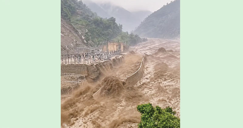
The intensity and risk of natural disasters in the Himalayan region are increasing due to the impact of global warming. Scientists see a direct role of climate change behind the recent devastating flash flood or sudden flood and landslide on the Nepal-Tibet border. However, glaciologists and geologists around the world are jointly conducting research to identify all the specific and immediate causes of this disaster.
According to some geoscientists, the deadly flood began when the bedrock beneath a glacier at an altitude of nearly 17,000 feet on Mount Langtang Lirung in northern Nepal collapsed on a massive scale. At the same time, a huge block of ice broke away from the glacier and crashed thousands of feet down into the valley. As a result, millions of tonnes of rocks and ice were crushed, creating a devastating flow of mud and water that struck populated areas. Researchers from different countries around the world have warned that the rise in global temperatures caused by the use of fossil fuels has caused the Himalayan ‘permafrost’—the frozen layer of soil, rock and organic matter that remains frozen for years—to begin melting rapidly. It had acted as a natural ‘glue’ that held ice and rocks together for thousands of years. As it melts, the foundations beneath glaciers are becoming extremely weak. Dr. Alton C. Byers, a senior researcher at the University of Colorado Boulder, has sarcastically called it “not-so-permanent permafrost.” The report also highlights that existing early-warning systems are not sufficient to deal with such disasters. Traditional river-based monitoring systems are becoming ineffective, particularly in the case of such sudden and rapidly moving floods. Therefore, researchers and policymakers must now consider new and complex risks such as permafrost degradation and rock collapse, rather than limiting Himalayan safety efforts only to monitoring glacial lakes.
Nearly 600 killed in Nepal, fears of new flooding
The death toll from the sudden catastrophic flooding on the Nepal-China border has risen to nearly 600. More than 1,500 people remain missing. Although the army and helicopters have been deployed to speed up rescue operations, reports of a newly formed artificial lake overflowing have raised fears of another major round of flooding in the region. Nepal’s disaster management authority said on Friday that the death toll from the devastating floods had risen to 538 in Nepal alone. However, Nepal Police said at least 547 people had been killed. State media in China has confirmed the deaths of five people in the Chinese part. More than 1,500 people in both countries are still missing, including tourists, pilgrims and local workers. Following the initial sudden flood caused by a glacier collapse high in the Himalayas, water accumulated there and formed a new artificial lake. The lake, located at an altitude of about 2,950 metres above sea level, faces the risk of overflowing and sending huge amounts of muddy water and debris downstream. Following reports that a dam had collapsed in the Tibet region, Nepal Police issued a high alert asking residents near the border to move to safe locations immediately.
Rescue operations resume, Chinese rescuers cutting through mud
Following the devastating flash flood and landslide in the Nepal-China border area, the overflowing water of a ‘barrier lake’ or artificial lake formed after the disaster has created fears of another severe flood. Fearing a worsening of the disaster, both Nepal and China were forced to temporarily suspend or significantly slow their rescue operations. However, rescue operations have since resumed. Despite taking all kinds of risks, China’s first professional rescue team has finally managed to reach the most severely affected and isolated area, Gyirong Port. The entire area has been covered by massive landslides and layers of mud, prompting eyewitnesses to compare it to “liquid concrete.” Officials said a landslide in the Tibet region blocked the river’s course, creating a huge artificial lake at an altitude of about 2,950 metres above sea level. As water levels rose due to mountain runoff and rainfall, the lake began overflowing, creating a severe risk of further destructive mudflows and landslides. As the situation became extremely concerning, local rescuers were ordered to move to safe locations. Despite this, the Chinese professional rescue team has crossed difficult routes and reached Gyirong Port using rafts, drones and heavy equipment, making desperate efforts to rescue people trapped there.
More than 90,000 people affected, many homes destroyed
A major humanitarian disaster and extensive damage have occurred due to the flash floods in the Nepal-China border area. The International Federation of Red Cross and Red Crescent Societies (IFRC) said at least 93,000 people have so far been directly and indirectly affected by the natural disaster. Speaking to journalists yesterday in Geneva, Switzerland, David Fisher, head of the IFRC’s delegation in Nepal, said thousands of homes in the Himalayan region had been completely destroyed by the flash floods. Rescue workers are facing serious challenges in reaching remote mountainous areas. David Fisher urged international relief agencies to plan for long-term rehabilitation rather than providing only ‘emergency survival assistance’. He said, ‘We must ensure that people are not forced to live under tents or plastic sheets for months on end.’
1.2-kilometre glacier collapse caused ‘liquid concrete’ flood
Scientists believe the devastating flash flood near the Nepal-Tibet border began with a major glacier collapse. Analysis of satellite images showed that a large section of a high-altitude glacier in the Nepalese part broke away and fell about 1.2 kilometres down into the valley. Ice, rocks, mud and sediment then combined to form an extremely powerful debris flow, which moved downhill and caused the devastating flood. Satellite images analysed by the National Remote Sensing Centre of the Indian Space Research Organisation (ISRO) showed that nearly two-thirds of the glacier had become detached. The Sentinel-2 satellite image of August 24 showed the glacier intact, while the Landsat-9 image of August 26 showed signs of a major collapse there.
Satellite analysis also showed that after the glacier collapse, an extensive flow path of ice and rocks descended towards the river. According to scientists, when a large mass of ice fell from an altitude of about 5,200 metres, it generated enormous gravitational energy. As a result, rocks, soil and other materials around the ice also descended at great speed. Mr. Dan Shugar, a geoscientist at the University of Calgary in Canada, said after analysing satellite images from Planet Labs that a large portion of the glacier crashed about 1,200 metres down onto the valley floor. According to him, the energy of the fall shattered the mass of ice and allowed it to pull surrounding loose materials along with it. Mr. Simon Cox, chief scientist at Earth Sciences New Zealand, said the collapsed glacier turned into a large debris flow as it descended. Rocks, sediment, trees and other materials along the way became part of it, making the flow heavier and more powerful. Mr. Hatim Sharif, a hydrologist at the University of Texas at San Antonio in the United States, compared such rapidly moving flows of mud and water to ‘liquid concrete’. According to him, such a flow does not simply move around structures like ordinary floodwater; rather, it can sweep away or destroy homes, roads, bridges, vehicles and even large rocks.
Sources: The New York Times, Reuters, AP, TOI.